I was up last night from 2:30 am to 3:30 am looking at clouds. Fun if you in meteorology, but not astronomy. I was trying to get my second good spectra of Epsilon Aurigae, a mysterious eclipsing binary (see earlier post) . Most of the people looking at this object are doing photometry, measuring the brightness of the star either visually or with a camera (usually a CCD digital camera). Since I have a larger telescope (16″) on a nice permanent equatorial mount, and since the star is bright at 3rd magnitude, I decided to take spectra. Most information about an astronomical object, chemical composition, doppler shifts, temperature, magnetic fields, come from looking at spectra.
Now you may not know that the reason the “arms race” for bigger and bigger scopes began in the early 1900’s to take spectra. You need telescopes that are big “light buckets”, because the light that the telescope would normally put into one point to make a nice image on a camera has to be spread out. The light is diluted by a prism or diffraction grating into a long strip of light to make a spectrum. If it’s a color camera it would look like smear from a rainbow. Since what use to land on a few pixels of my camera is now landing on several hundred the image is MUCH dimmer. So to take a good spectra you either have to take a much longer exposure, stick to much brighter objects, or get a bigger telescope. Brightness or exposures increase by a factor of 100, or for you astronomy experts about 5 magnitudes in brightness.
Now instruments are stupid (as are theoretical physicists trying to be observational astronomers at 3:00 am in the MORNING), they don’t know how the position of the light in the camera is related to wavelength. So when I take the spectra of a star, I also take a spectra of a Mercury lamp with known spectra lines for calibration. I take both spectra, making sure I don’t change anything with the camera or telescope (like focus). That way I can tell my computer that this pixel means this wavelength (color). As Shown below:
Raw First Spectra of Epsilon Aurigae (9/27/09)
Mercury Spectrum used for calibration
Now you may notice the star’s spectrum has dark lines because it’s an absorption spectra, while the mercury spectrum is a bright line or emission spectra. Once the computer knows what the wavelengths are we can look at a plot of a star’s spectrum, a lot easier to read that the picture. There are other steps, like subtracting out spectral lines from the Earth’s atmosphere, but I thought you’d like to see a preliminary result.
Low resolution preliminary spectra of Epsilon Aurigae
With any luck, clear weather, we’ll be able to take some more spectra in the next few days to see any changes in the spectra as the eclipse stars. That way we hope to learn about the object causing the eclipse.
School Teachers Aid in the Search for Killer Asteroids July 29, 2009Posted by jcconwell in Asteroids, Astronomy. Tags: Asteroid, Astronomy, EIU, NEOadd a comment
My graduate class in astronomy for science teachers just completed its summer course.
Teachers learning the ins and outs of asteroid hunting
One of the last thing we do is to have some outside speakers come in. On Monday, Bob Holmes head of the Astronomical Research Institute based here in Charleston, Illinois, spoke to the students about one of his NASA projects that he involved with. Searching for NEO’s (Near Earth Objects)
bd81 asteroid discovered
ARI’s telescopes can take more than 1000 photos a night, while hunting for objects that can cross Earth’s orbit, like the movie above. So high school teachers and their students are needed to to go through and hunt for objects that may hit us. The software is free, and if a new object is found, the student get credit and published in the minor planet circular at Harvard University. For more information, if you, and your students might be interested in this search contact ARI: http://ari.home.mchsi.com/contact_astro_research.htm
or
INTERNATIONAL ASTRONOMICAL SEARCH COLLABORATION
http://iasc.hsutx.edu/index.htm
And for information about the software used Astrometrica:
http://iasc.hsutx.edu/index_files/Page389.htm
Hubble back just in time for Jupiter July 26, 2009Posted by jcconwell in Astronomy, planets. Tags: Jupiter, planetsadd a comment
The Hubble space telescope took time out from calibration to snap the clearest photo of the recent impact on Jupiter.
Hubble Photo of Impact on Jupiter
Scientists used the telescope Thursday to capture what they call the “sharpest visible-light picture” so far of the expanding gash. An amateur stargazer in Australia spotted the impression last Sunday. If you are interested in viewing the dark spot yourself, look to the article at “Universe Today”, which gives the times of viewing for the next few days: http://www.universetoday.com/2009/07/24/viewing-the-jupiter-impact-with-your-telescope/
Are we still looking for other worlds? July 25, 2009Posted by schsscience in Astronomy, planets. Tags: dwarf planet, exoplanet, planetsadd a comment
What ever happened to extrasolar planets? They used to make the news. The search for these distant worlds, however, is as fervent as ever. As better technology and new techniques have been developed, finding them has become commonplace. To date, the known number of exoplanets, as they are commonly known, has increased to over 350. But what are exoplanets, exactly? How are they detected? And why are we looking for them?
The term extrasolar planet refers to any planet orbiting a star other than our sun. Though their presence had been predicted for hundreds of years, the first one wasn’t found until 1992. We didn’t have the technology to detect them. After all, compared to its parent star, even a Jupiter-sized planet is very small and dim. Furthermore, most of these planets orbit close to their parent star, making it even harder to distinguish them. Thus far most exoplanets found have been very large, multiple times larger than Jupiter.
Astronomers use several methods to search for and identify exoplanets. Each method has its advantages and disadvantages. Depending on the distance, the size, or the orientation of a planet’s orbital plane one method may be more effective than another. Sometimes more that one method can be used on the same planet giving a more complete picture of what the planet may be like.
The most successful method for detecting exoplanets is the radial-velocity or Doppler shift method. In this method, the presence of a planet is detected by measuring tiny changes in the frequency of the star’s light. As a planet orbits a star it causes it to wobble very slightly about the system’s center of mass (see image below). As the star is pulled away from us its spectrum is shifted towards the red end, and as it is pulled towards us it is shifted to the blue end. This method only works if the planet’s orbital plane is aligned parallel to the Earth’s orbit. It is not possible to determine the size of these planets using this method.
Click here to see an animation of the wobble.
The first planets were detected using pulsar timing. Pulsars are neutron stars that rotate very quickly. As they rotate, they emit flashes of radio waves at very regular intervals like a light-house. These flashes can be detected and timed. A planet orbiting a pulsar will cause very slight variations in the timing of these flashes which can be used to detect it.
When a planet’s orbital plane is perpendicular to Earth’s, another method known as astrometry works well to detect the star’s tiny wobble. In this method the star’s position is precisely measured against the background stars. Tiny shifts in its position indicate the tug of a planet orbiting it. Astronomers are hopeful that this method will lead to the detection of smaller Earth-sized planets.
In transit photometry the dimming of a star is detected as a planet crosses in front of it. Using this method, astronomers can measure the size of a planet. Even more intriguing is that astronomers can sometimes determine the absorption spectrum of a planet’s atmosphere as the star’s light passes through it. This allows them to determine the composition of the planet’s atmosphere.
For the average person the most exciting method of observation is direct imaging. Unfortunately this requires a rare set of conditions. The method works best when the planet’s orbital plane is perpendicular to Earth’s, the planet is bright and its star dim, and the star is relatively close to Earth. So far only a few planets have been found using this method.
In November of 2008 the Hubble telescope imaged a planet orbiting the star Fomalhaut. The planet is estimated to be about 2 times the size of Jupiter and is extraordinarily bright. Since then several others have been seen.
A trio of planets (faint dots indicated with arrows) orbits the young, massive star HR 8799, some 130 light-years from Earth. Discovered using the Hawaii Keck telescope. Credit: Marois, National Research Council/Canada, Keck
In recent months, astronomers have been able to identify planets thought to be more Earth-like than the gas giants they have been finding so far. These large “super-Earths” lack the dense atmosphere of the gas giants and have a dense rocky composition. So far around 30 such planets have been found, but scientists believe that they probably far outnumber the gas giants.
There are some exciting implications of these recent finds. If a rocky planet orbits a main sequence star like our sun in the so-called “Goldilocks zone, it is possible that it could support life. In the near future, Astronomers hope to analyze the atmospheres of these super-Earths using new telescopes such as the James Webb Telescope, scheduled for launch in 2013. If they can find signs of carbon dioxide and water, it could mean that the planet may support life. On the other hand, if they find oxygen and methane, it may indicate that life already exists there!
Top 10 Ways the Universe Could Kill Us! July 24, 2009Posted by kfarley in Asteroid, Astronomy, Cosmology. Tags: Asteroid, blackholes, Gamma Ray Burst, neutron star4 comments
Asteroid Impact
Asteroids and other near-Earth objects (NEOs) come near the Earth more frequently than one would guess. Question: Why don’t we ever hear of these objects hitting the Earth? Answer: Because they don’t. More often than not our atmosphere causes great friction on these solar bodies causing them to burn up. This happens before the asteroids can go through our atmosphere and hit the Earth. Our atmosphere can be a good friend to us – protecting us from solar debris that could potentially hit Earth and end civilization as we know it. If an asteroid were to make it through our atmosphere it becomes classified as a meteor. It is theorized that a large meteor hit the Earth about 65 million years ago wiping out the dinosaurs. According to NASA, a meteor about 1/5 that size will hit the Earth about once or twice every million years. If Earth did get hit by an asteroid of that caliber we would most likely not survive. I haven’t heard of an asteroid that size hitting the Earth in quite some time, maybe we’re overdue. With ≈6.7 billion people in the world your chance of seeing the Earth hit by that size meteor is…well, you do the math. To learn more information on NEOs check out NASA’s FAQs.
Illustration of an asteroid that could have wiped out the dinosaurs.
Solar Flare
A solar flare is a huge explosion of energy in the Sun’s atmosphere. Think of it like a giant spike of light and heat that suddenly rises off the surface of the Sun. The rays emitted (mainly X-rays and UV rays) from this explosion are strong enough to disrupt radio communication on Earth! The flares can influence the surface of Earth by having an effect on our weather. Just outside our atmosphere, the flares can present radiation hazards to spacecraft and astronauts. The solar flares can also produce streams of highly energetic particles in our atmosphere. These highly energetic particles help in the production of the beautiful aurora borealis! On the other hand, the radiation from solar flares also pose incredible complications that could arise during manned missions to Mars, the Moon, or other space travel. Satellites’ orbital paths can also be disrupted by the solar flares. Kind of a catch-22, amazing Northern lights produced but also possible space travel limit. Hmm…
Aurora borealis co-created by solar flares.
Supernova
Ever had someone shine a flashlight in your eyes? Not very nice, huh? Think of shining a light in your eyes a billion times brighter! A supernova is just that – an exploding star billions of times brighter that our Sun. After the core of a star collapses it emits great energy as a flash of growing intensity before fading back out of sight. If a supernova was close enough and aimed toward our solar system, it could wipe out our atmosphere. Our planet would overheat from UV rays causing mass extinction. It’s messy too. The supernova will throw large clouds of dust and gas into space that could exceed 10 times the mass of our Sun. We should be thankful for supernovae in a way. It is hypothesized supernovae created the heavier elements such as gold, iron, and uranium found here on Earth.
Supernova.
Gamma Ray Burst
Gamma ray bursts (GRBs) are flashes of gamma rays that last from fractions of a second to almost an hour. They normally last a few seconds and usually come from outside our galaxy. They are the most luminous (electromagnetic) events that occur in the universe. GRBs often have an afterglow affect as longer wavelengths travel from the blast. The blast from a GRB in our galaxy would definitely cause mass extinction from the intense rays that would encompass our planet. It is hypothesized such an event caused the mass planetary extinction on Earth about 444 million years ago. A GRB depleted the ozone layer leaving our planet helpless to direct UV rays that heated and kill organisms until food chains were depleted.
P.S. Gamma rays gave the Hulk his powers (I think that is fictional though).
Illustration of a gamma ray burst hitting a planet like Earth.
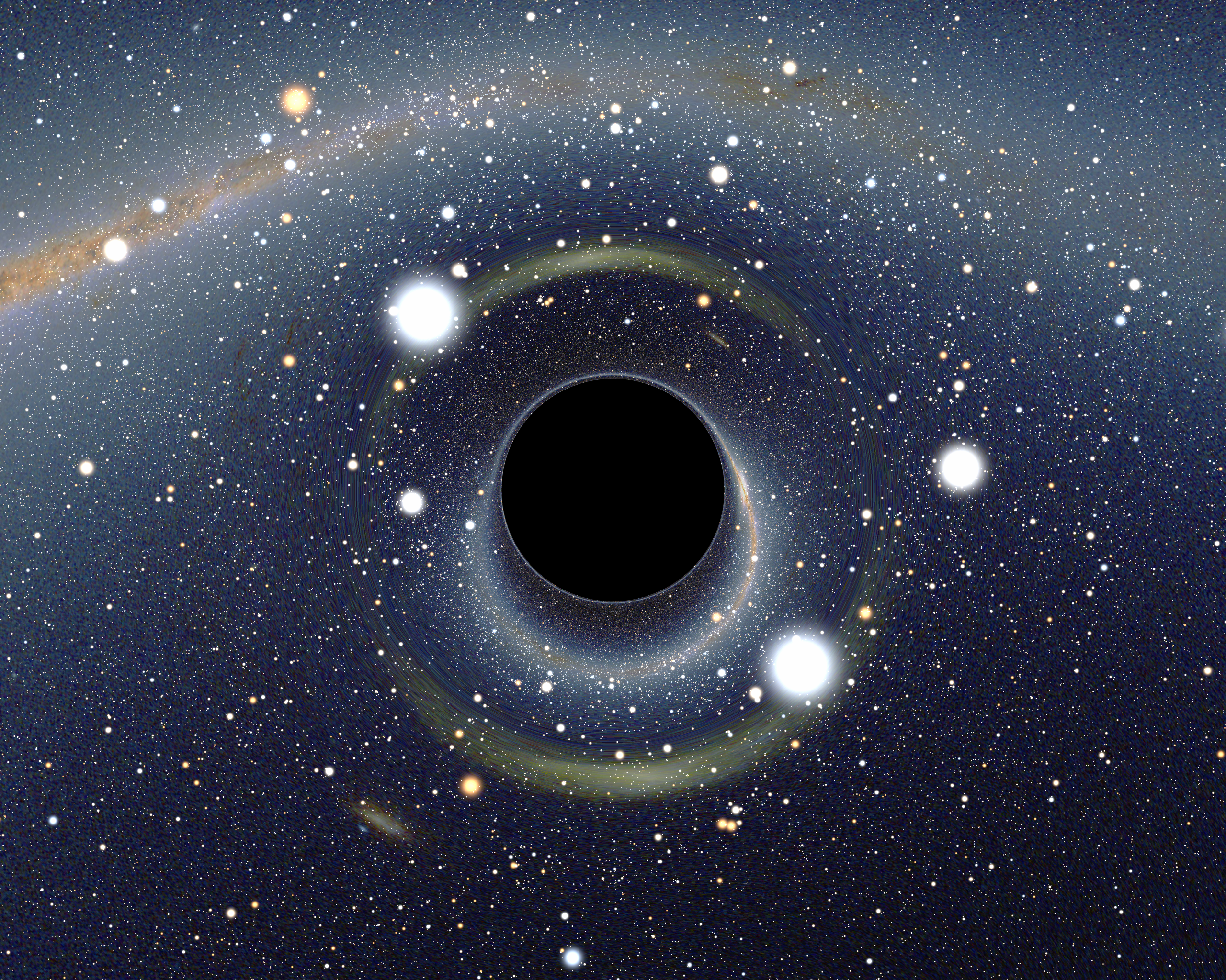
Black hole
Black holes are areas in space in which the gravitational field is so incredible that nothing can escape its pull. Not even light can be reflected from this object, hence its name. It is virtually impossible to escape a black hole once its immense gravitational pull has a hold of you. The point of no return at a black hole is called the horizon. It is an area just outside a black hole where the gravitational pull begins. Once you hit the horizon of a black hole your fate is sealed and escape from the black hole is futile. Knowing not even light can escape the pull of the black hole, you would have to travel faster than the speed of light to escape. If you were to see an object being pulled into a black hole (assuming the object can still reflect light), it would become extremely distorted. The gravitational pull is so intense, the part of the object entering the black hole first would stretch out of normal proportions. For example, if you were floating through space with your arms in front of you (Superman-style) and began to be sucked into a black hole, your arms would stretch out incredibly long before the rest of your body. Black holes are also very massive. They can range anywhere from 10 times to a million times the mass of our Sun. Currently, there are no known black holes in our galaxy. This known with the fact our space travel is limited to our Moon, you are probably safe from a black hole fate.
Illustration of what a black hole over the Milky Way might look like.
Death of Sun
The Sun goes through different stages during its life cycle. It’s about halfway through the “main sequence” before it goes into a different star phase. The Sun will most likely turn into a Red Giant star peaking at its highest luminosity. The Sun will then start to burn out as it turns into a small dwarf star. The Sun won’t turn into a Red Giant for another 5 billion years or so. A more immediate problem, as the Sun moves toward the next stage it becomes gradually warmer. It will get really hot. Life on Earth most likely won’t make it to the Red Giant stage. The Earth will warm up to the point where life will not be sustainable. The Sun has slowly been warming up ever since its birth. The Sun used to not be as hot, one of the reasons life didn’t always exist on the Earth. Just as the warmth of the Sun allowed life on Earth, it will also take it away.
The life cycle of our Sun.
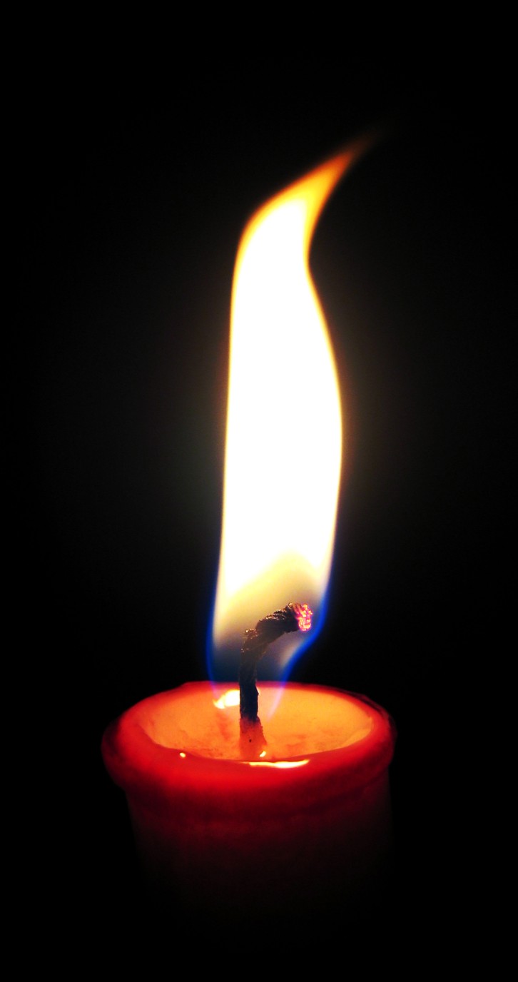
Heat Death of Universe
The heat death of the universe occurs as all the stars and other universal matter continues to expand and uses up its energy or “burns out.” It’s like letting a candle burn and not blowing it out. Eventually it’s going to use up the wax and wick until it can’t burn anymore. The universe runs on “free” energy that is not endless. At some point the fuel for the universe will run out cutting of the energy for the cosmic bodies that give us life (namely our Sun). This probably won’t be happening anytime soon. It’s estimated the energy will run out after black holes vanish in about 10100 years (according to Hawking’s radiation). That’s one big candle!
The flame of life.
The Big Rip
Just like how it sounds, all matter of the universe will be ripped apart. We’ve all heard that the universe is expanding. What would happen if the expansion increased at an accelerated rate? If the universe expanded much faster than it is now, all the galaxies, stars, planets, dust, etc. would be ripped apart! Think of it like a twizzlers. If you pull slowly you can stretch out the twizzlers pretty far. If you stretch too fast the twizzlers will just snap in half. This is a possibility for our universe. The hands pulling on our universe is something called dark energy. Dark energy is a hypothetical energy that saturates all our universe. It is theorized it helps our universe expand – at an accelerating pace. This means the expansion is moving at a faster and faster rate as time goes by. Eventually the universe will reach that point where it is pulling to fast, ripping apart everything. What happens when everything is ripped apart and away from each other? No one knows.
The Big Rip.
Cannibal Galaxies
Cannibal galaxies occur when a smaller galaxy is eaten by a larger galaxy! Natural selection at its best. Galaxies are gravitationally bound collections of stars, stellar bodies such as planets, space dust, and other objects. You are probably most familiar with the Milky Way galaxy (you should know this one, we live in it). Scientists can now detect our Milky Way galaxy is currently tearing apart and engulfing the Sagittarius galaxy as you read this! Closer to home than you might have expected. I guess we are saved this time but poor little Sagittarius galaxy…
Larger galaxy engulfing a smaller galaxy. (Swinburne)
Pulsar
When a star collapses on itself a neutron star is left behind. If we were to survive this giant explosion, we would have a new problem of pulsars to deal with. A pulsar is a neutron star that emits rays of electromagnetic radiation. Electromagnetic radiation is rays that vary depending on their frequency and wavelength. Some rays provide us with the visible light we use every day. Other rays below or above the spectra can be very harmful to us. For instance, radio waves (beyond red in the visible spectra) can vibrate the cells in your body heating them up to a deadly temperature while gamma rays (beyond blue in the visible spectra) can stop the function of the cells in your body. Oddly enough, both radio waves and gamma rays are used to treat different ailments.
The Vela Pulsar. NASA pic.
Earth’s Deadliest Nemesis: The Gamma Ray Burst? July 24, 2009Posted by heisman50 in Astronomy, Gamma Ray Bursts. Tags: Astronomy, Gamma Ray Burstadd a comment
Courtesy of: http://startswithabang.com/wp-content/uploads/2009/01/swift-gamma-ray-lg.jpg
Maybe not right now, nor maybe not even tomorrow, but it could happen. Life on Earth could be in serious jeopardy. And the enemy is not anyone or anything on this planet, but rather the workings of an enemy 5000 to 8000 light years away. The sad thing is, there may be no way to see it coming, and most certainly nothing we can do about it. There are over 300,000 gamma ray bursts a year so there is a chance that one could be directed straight towards Earth.
When an enormous star detonates into a supernova, radioactive nuclei are shot out into interstellar space releasing countless photons. This radiation tends to be very low wavelength, high frequency in the gamma ray portion of the electromagnetic spectrum.
Courtesy of http://www.antonine-education.co.uk/physics_gcse/Unit_1/Topic_5/em_spectrum.jpg
To quantify the amount of energy we can use Plank’s Law. According to Plank’s law the energy of a photon can be expressed by the following equation:
E = energy of a photonh = Plank’s constant = 6.625 x 10⁻³⁴ J*s or 4.135 x 10⁻¹⁵ eV*sλ = wavelength of light
Using this equation, the photons of gamma rays will have the highest energy of all as their wavelength is exceptionally small. Thus, a gamma ray photon would produce the largest amount of energy of any type of electromagnetic radiation in the electromagnetic spectrum. While the release of one photon may seem small, the radiation from a supernova directed towards Earth may carry the energy of seemingly countless photons. The result is a tremendously high amount of energy bound for the Earth. To put the amount of energy into perspective, Dr. Edo Berger, an astrophysicist at Harvard University, the energy released by a gamma ray burst is equivalent to powering the world for 1027 years.[1]
The effects could be substantial. One scenario popularized by the History Channel’s series Mega Disasters depicts the gamma radiation attacking and destroying the ozone layer of the Earth while releasing a smog of nitrogen oxide, nitrogen dioxide, and dinitrogen trioxide compounds that effectively block the Sun, break down ozone and cause acid rain. Without the Sun’s rays, a global cooling would exist and plant life could not continue, abruptly disrupting the food chain for all on Earth. According to Dr. Derek Fox, an astrophysicist at Penn State University, a gamma ray burst could irradiate the Earth to the equivalence of 100,000 atom bombs exploding just outside of the Earth’s atmosphere.[2]
Courtesy of: http://www.phys.ncku.edu.tw/~astrolab/mirrors/apod/image/9904/wr104_sslkeck_big.jpg
So how likely is the threat? The biggest possibility comes from WR104 that sits about 8000 light-years away. If directed perfectly at Earth, the effect on life could be devastating and the fate of the planet may be in jeopardy. But don’t get all worked up just yet. According to David Thompson, a NASA astrophysicist and deputy project director on the Fermi Gamma-ray Space Telescope, the likelihood of a gamma ray burst from WR104 is equivalent to, “the danger I might face if I found a polar bear in my closet in Bowie, Maryland. It could happen, but it is so unlikely that it is not worth worrying about.”[3]
1.http://www.astro.caltech.edu/~ejb/faq.html2. History Channel. MEGA DISASTERS: GAMMA RAY BURST ©20073. http://blogs.discovermagazine.com/badastronomy/2008/03/03/wr-104-a-nearby-gamma-ray-burst/
Orion July 23, 2009Posted by heritageag in Astronomy. add a comment
Orion as depicted in Urania's Mirrow, a set of constellation cards published in London in 1825.
Lauren Hopper has her blog at: http://heritageag.wordpress.com/
This great hunter in the sky has been my favorite constellation for as long as I can remember. Any clear dark night available I try to find those three diamonds in his belt.
The constellation Orion is one of the largest, most obvious and most recognizable constellations in the sky. Orion includes a group of stars known as the ‘belt’ of Orion. These three bright stars in a row (aka. The Three Kings) make up the line of his belt. Surrounding the belt are four bright stars, which are considered to represent the outline of Orion’s body. Descending from the belt is a smaller line of stars that make up the hunter’s sword. One of these stars is not exactly a star but the Orion Nebula.
The surrounding constellations are often shown to be related to Orion. He is shown standing next to the river Eridanus. He is accompanied by his two hunting dogs Canis Major and Canis Minor. Orion is also shown fighting Taurus the bull. He is also often times illustrated hunting
Orion has often times been a useful tool to find other stars and constellations. If you extend the line of Orion’s belt out southeastward you can find the star Sirius. If you extend his belt out northwestward you will find the star Aldebaran. If you extend a line eastward across his two shoulders you will find the star Procyon. You can also extend a line through Rigel and Betelgeuse and find the stars Castor and Pollux.
Illustration showing how to use Orion to find neighbor stars.
Some other interesting facts about the constellation Orion are: there is a meteor shower that reaches its peak around Oct. 21 each year. It’s named the Orionid Meteor Shower. It has been know that you can see at least 20 meteors per hour at times.
Orionids Meteor Shower
The constellation Orion is over 1,000 light-years deep. It’s nearest star Rigel being 900 light-years away and its farthest Kappa which is around 2,100 light years away. The constellation is over 700 light-years wide. You can look for Orion high in the SE in the January early evenings or just after twilight on the meridian in February. In March it will still be noticeable in the early evenings in the SW.
Information from:
http://en.wikipedia.org/wiki/Orion_(constellation)
Craig Crossen & Wil Tirion “Binocular” Astronomy 2nd Edition”
http://www.nightskyhunter.com/
Total Solar Eclipse on July 22, 2009 July 22, 2009Posted by misskblog in Astronomy. add a comment
TOTAL SOLAR ECLIPSE COMING UP ON JULY 22, 2009
On Wednesday, July 22nd, a total solar eclipse will take place. The thought of this eclipse takes me back to my years in junior high when our teacher prepared us for an upcoming solar eclipse. It was to take place during a school day in either around 1993 and everyone was excited about this fantastic astronomical event. We made pinhole eclipse viewers using shoe boxes and black paper and every student got a pair of solar glasses to wear so that we could lie on our backs and stare up at the sky waiting for just the right moment. I will never forget the hush that came over the area as the moon crossed in front of the Sun. Everything on the playground and school yard went very dim and things got very quiet. Birds even stopped chirping, confused by the lack of daylight. What an amazing and teachable moment!
The upcoming solar eclipse will not, however, be able to be seen from North America. It will take place in a narrow swath that goes across half the Earth. At sunrise on July 22, 2009, the moon’s umbra—the cone-shaped part of the moon’s shadow—will fall on India’s Gulf of Khambhat. The path of the moon’s umbral shadow will then cross through Nepal, Bangladesh, Bhutan, Myanmar and China. The cities in China that will see the total eclipse of the Sun are as follows: Beijing, Wulumuqi, Changchun, Xining, Xi’an, Shanghai, Wuhan, Chongqing, Hong Kong, and Kunming. In Nepal the sun will be totally eclipsed in Biratnagar. In Taiwan, there will be a partial eclipse of the Sun in Taipei. And in Mongolia, it will be seen from Ulaanbaatar. Japan has partially eclipsed sun in Sapporo, Tokyo and Fukuoka. After leaving mainland Asia, the path crosses Japan’s Ryukyu Islands and curves southeast through the Pacific Ocean. A partial eclipse will also be seen within the much broader path of the Moon’s penumbral shadow, which includes most of eastern Asia, Indonesia, and the Pacific Ocean.
This solar eclipse is the longest total solar eclipse that will occur in the twenty-first century, and will not be surpassed in duration until June 13, 2132. Totality will last for up to 6 minutes and 39 seconds, with the maximum eclipse occurring in the ocean at 02:35:21 UTC about 100 km south of the Bonin Islands, southeast of Japan. The umbra travels along a track that is about 15,150km (about 9414 miles) long and covers 0.71 percent of the earth’s surface area over a course of three hours and 25 minutes. The North Iwo Jima island is the landmass with totality time closest to maximum.
The Times of India publication was urging its readers to get out and enjoy the eclipse, as it will be the last one visible for quite some time. The next total solar eclipse that can be viewed from India will occur on June 3, 2114. As a teacher now myself I would love the opportunity to share this awe-inspiring display with my students. That will be some time from now, as the next total eclipse that can be seen from North America is predicted to be on August 21, 2017. I guess that will give me plenty of time to prepare my students!
Aurora Borealis – Best Light Show on Earth July 21, 2009Posted by chemfan in Astronomy, Solar and Space weather. Tags: Astronomy, Aurora Borealis, Solar System1 comment so far
Sergey Zinovichik has his blog at: http://chemfan.wordpress.com/
Aurora Borealis or commonly named The Northern Lights is a natural display of lights in the North Pole regions of our globe. The lights appear as flowing streams of color in the sky taking different shapes and contours and often look like a multicolored curtain coming down from outer space.
The light show comes to us courtesy of our Sun. Electrically charged particles produced on the Sun are ejected in all directions and a great amount of them head toward Earth. As these particles (called solar wind) encounter the Earth’s outer regions, the magnetic field of the Earth begins to interact with the particles.
What results is a change in energy and direction of the particles: they head along magnetic field lines toward the poles of Earth. Just like a bar magnet has its field lines returning at the opposite ends so the Earth’s magnetic lines come together around the poles. This is why the aurora borealis is brightest and most easily seen in the northern regions of our planet.
Image taken from Wikipedia.org
The colors that we see in the aurora get produced from the collision of solar wind with atoms and molecules of our atmosphere. Every atom and molecule has around them orbiting electrons. The electrons sit in different energy levels with the highest energy electrons being furthest from the nucleus.
Although the orbits of electrons around the atom are complicated we can represent their arrangement with a simple picture:
We can see the first important aspect of orbiting electrons: They can only have certain energies analogous to planets orbiting at certain distances from the Sun.
When a fast moving solar wind particle collides with an atom the electrons in the atom “jump up” to a higher energy level. The electrons in this excited state are usually unstable and will eventually fall back down releasing the energy they absorbed. The way electrons release energy is in the form of electromagnetic radiation or what we would call light.
Image taken from HowStuffWorks.com
The type of light emitted depends on the type of atom that was excited. This is because an oxygen atom’s energy levels differ somewhat from a nitrogen or helium atom. The energy released corresponds to a certain visible color and the color corresponds to the energy that was lost as the electron returned to its previous state. The colors we see in aurorae are regular because the energy levels in an atom are the same and because electrons can assume only certain quantized energies.
In some aurora red and green colors are prevalent. This is characteristic of oxygen atoms being excited and releasing energy. Molecular nitrogen can produce blue or violet colors. Helium in rare occasions can produce orange light. Compounds of oxygen and nitrogen can produce their own characteristic light.
When a mixture of different colors comes together the aurora we see is colored white just like the visible light from the sun put together from all the colors of the rainbow appears white.
Image Taken from APOD
The beauty of the Northern Lights can sometimes come down from the polar region and become visible at lower latitudes. This is due to periods of high solar wind corresponding to unusual activity on the Sun. In August and September of 1859 The Northern Lights were seen from the Midwestern region of the United State and were very bright. Worldwide reports of unusual aurora intensity and frequency that year were confirmed by magnetographs recording high levels of magnetic activity from the Kew observatory in England.
The southern pole of the planet experiences a similar phenomenon called Aurora Australis or Southern Polar lights and this light show is visible only in the southern hemisphere.
If you are fortunate enough to live in a part of the globe that has auroral displays you will probably agree that the light show that nature displays cannot be rivaled by anything humans can create.
Image taken from APOD
New Impact on Jupiter July 21, 2009Posted by jcconwell in Asteroid, Astronomy, planets. Tags: Asteroid, Jupiter, Solar Systemadd a comment
Taken from the article by Nancy Atkinson at Universe Today
Amateur astronomer Anthony Wesley from Canberra, Australia captured an image of Jupiter on July 19 showing a possible new impact site. Anthony’s image shows a new dark spot in the South Polar Region of Jupiter, at approximately 216° longitude in System 2. It looks very similar to the impact marks made on Jupiter when comet Shoemaker-Levy 9 crashed into the gas giant in 1994. (But read the Bad Astronomer’s post that the black spot could also be weather.)UPDATE (7/20): It has been confirmed this is an impact on Jupiter. Mike Salway shared the news Glenn Orton from JPL has imaged the Jupiter black spot with the NASA Infrared Telescope and he has confirmed it’s an impact.
Jumat, 27 November 2009
Sabtu, 21 November 2009
Gunung Everest
Dari Wikipedia bahasa Indonesia, ensiklopedia bebas
| Everest | |
|---|---|
 Puncak Everest dilihat dari Kala Patthar | |
| Ketinggian: | 8.850 m (Urutan ke-1) |
| Koordinat: | 27°59′16″LU,86°56′40″BT |
| Letak: | Perbatasan Nepal–Tibet |
| Barisan pegunungan: | Himalaya |
| Pencapai puncak pertama: | 29 Mei 1953 oleh Edmund Hillary dan Tenzing Norgay |
| Rute pendakian termudah: | South Col (Nepal) |

Gunung Everest (bahasa Inggris: Mount Everest) adalah gunung tertinggi di dunia (jika diukur dari paras laut). Rabung puncaknya menandakan perbatasan antara Nepal dan Tibet; puncaknya berada di Tibet. Di Nepal, gunung ini disebut Sagarmatha (सगरमाथा, bahasa Sansekerta untuk "Dahi Langit") dan dalam bahasa Tibet Chomolangma atau Qomolangma ("Bunda Semesta"), dilafalkan dalam bahasa Tionghoa 珠穆朗瑪峰 (pinyin: Zhūmùlǎngmǎ Fēng).
Gunung ini mendapatkan nama bahasa Inggrisnya dari nama Sir George Everest. Nama ini diberikan oleh Sir Andrew Waugh, surveyor-general India berkebangsaan Inggris, penerus Everest. Puncak Everest merupakan salah satu dari Tujuh Puncak Utama di dunia.
[sunting] Ukuran
Radhanath Sikdar, juru ukur dan pakar matematika dari Bengal, merupakan orang pertama yang menyatakan Puncak Everest sebagai puncak tertinggi melalui perhitungan trigonometrik pada 1852. Perhitungan ini dilakukan menggunakan teodolit dari jarak 150 mil jauhnya di India. Sebagian rakyat India percaya bahwa puncak tersebut semestinya dinamakan menurut Sikdar, bukan Everest.
Gunung ini mempunyai ketinggian sekitar 8.850 m; walaupun terdapat variasi dari segi ukuran (baik pemerintah Nepal maupun Cina belum mengesahkan ukuran ini secara resmi, ketinggian Puncak Everest masih dianggap 8.848 m oleh mereka). Gunung Everest pertama kali diukur pada tahun 1856 mempunyai ketinggian 8.839 m, tetapi dinyatakan sebagai 8.840 m (29.002 kaki). Tambahan 0,6 m (2 kaki) menunjukkan bahwa pada masa itu ketinggian yang tepat sebesar 29.000 kaki akan dianggap sebagai perkiraan yang dibulatkan. Perkiraan umum yang digunakan pada saat ini adalah 8.850 m yang diperoleh melalui bacaan Sistem Posisi Global (GPS). Gunung Himalaya masih terus bertambah tinggi akibat pergerakan lempeng tektonik kawasan tersebut.
Gunung Everest adalah gunung yang puncaknya mencapai jarak paling jauh dari paras laut. Dua gunung lain yang kadangkala juga disebut sebagai "gunung tertinggi di dunia" adalah Mauna Loa di Hawaii, yang tertinggi jika diukur dari dasarnya pada dasar tengah laut, tetapi hanya mencapai ketinggian 4.170 m atas paras laut dan Gunung Chimborazo di Ekuador, yang puncaknya 2.150 m lebih tinggi dari pusat bumi dibandingkan Gunung Everest , karena Bumi mengembung di kawasan katulistiwa. Bagaimanapun juga, Chimborazo hanya mencapai ketinggian 6.272 m di atas paras laut, sehingga bahkan bukan merupakan puncak tertinggi di Andes.
Dasar terdalam di lautan lebih dalam dibandingkan ketinggian Everest: Challenger Deep, terletak di Palung Mariana, begitu dalam hingga seandainya gunung Himalaya diletakkan di dalamnya, masih terdapat hampir 1,6 km air menutupinya.
[sunting] Lihat pula
[sunting] Pranala luar
- (en) EverestHistory.com, Alur waktu Gunung Everest
- (en) MountEverest.net
- (en) Halaman National Geographic tentang Everest
Peralatan pribadi
– also called Sagarmāthā (Nepali: सगरमाथा), Chomolungma or Qomolangma (Tibetan: ཇོ་མོ་གླང་མ) or Zhumulangma (Chinese: 珠穆朗玛峰 Zhūmùlǎngmǎ Fēng) – is the highest mountain on Earth, and the highest point on the Earth's continental crust, as measured by the height above sea level of its summit, 8,848 metres (29,029 ft). The mountain, which is part of the Himalaya range in Asia, is located on the border between Sagarmatha Zone, Nepal, and Tibet, China.

 Aerial view of Mount Everest from the south
  Southern and northern climbing routes as seen from the International Space Station.
 A view of Everest southeast ridge base camp. The Khumbu Icefall can be seen in the left. In the center are the remains of a helicopter that crashed in 2003.
  Rongbuk Monastery in Tibet with the north side of Everest in the background.
  Northern panoramic view of Everest from Tibetan Plateau

2004 photo mosaic the Himalayas with Makalu and Mount Everest from the International Space Station, Expedition 8.  The last rays of sunlight on Mount Everest on 5 May 2007
In 1856, the Great Trigonometric Survey of India established the first published height of Everest, then known as Peak XV, at 29,002 ft (8,840 m). In 1865, Everest was given its official English name by the Royal Geographical Society upon recommendation of Andrew Waugh, the British Surveyor General of India at the time. Chomolungma had been in common use by Tibetans for centuries, but Waugh was unable to propose an established local name because Nepal and Tibet were closed to foreigners.
The highest mountain in the world attracts climbers of all levels, from well experienced mountaineers to novice climbers willing to pay substantial sums to professional mountain guides to complete a successful climb. The mountain, while not posing substantial technical climbing difficulty on the standard route (other eight-thousanders such as K2 or Nanga Parbat are much more difficult), still has many inherent dangers such as altitude sickness, weather and wind. By the end of the 2008 climbing season, there had been 4,102 ascents to the summit by about 2,700 individuals.[4] Climbers are a significant source of tourist revenue for Nepal, whose government also requires all prospective climbers to obtain an expensive permit, costing up to US $ 25,000 per person.[5] Everest has claimed 210 lives, including eight who perished during a 1996 storm high on the mountain. Conditions are so difficult in the death zone that most corpses have been left where they fell. Some of them are visible from standard climbing routes.[6]
Contents[hide] |
Identifying the highest mountain
In 1808, the British began the Great Trigonometric Survey of India to determine the location and names of the world's highest mountains. Starting in southern India, the survey teams gradually moved northward using giant 500 kg (1,100 lb) theodolites (each requiring 12 men to carry) to measure heights as accurately as possible. They reached the Himalayan foothills by the 1830s, but Nepal was unwilling to allow the British to enter the country because of suspicions of political aggression and possible annexation. Several requests by the surveyors to enter Nepal were turned down.[7]
The British were forced to continue their observations from Terai, a region south of Nepal which is parallel to the Himalayas. Conditions in Terai were difficult owing to torrential rains and malaria — three survey officers died from malaria while two others had to retire owing to failing health.[7]
Nonetheless, in 1847, the British pressed on and began detailed observations of the Himalayan peaks from observation stations up to 240 km (150 mi) away. Weather restricted work to the last three months of the year. In November 1847, Andrew Waugh, the British Surveyor General of India made a number of observations from Sawajpore station located in the eastern end of the Himalayas. At the time, Kangchenjunga was considered the highest peak in the world, and with interest he noted a peak beyond it, some 230 km (140 mi) away. John Armstrong, one of Waugh's officials, also saw the peak from a location further west and called it peak 'b'. Waugh would later write that the observations indicated that peak 'b' was higher than Kangchenjunga, but given the great distance of the observations, closer observations were required for verification. The following year, Waugh sent a survey official back to Terai to make closer observations of peak 'b', but clouds thwarted all attempts.[7]
In 1849, Waugh dispatched James Nicolson to the area. Nicolson was able to make two observations from Jirol, 190 km (120 mi) away. Nicolson then took the largest theodolite and headed east, obtaining over 30 observations from five different locations, with the closest being 174 km (108 mi) away from the peak.[7]
Nicolson retreated to Patna on the Ganges to perform the necessary calculations based on his observations. His raw data gave an average height of 9,200 m (30,000 ft) for peak 'b', but this did not take into account light refraction which distorts heights. The number clearly indicated, however, that peak 'b' was higher than Kangchenjunga. Unfortunately, Nicolson came down with malaria and was forced to return home, calculations unfinished. Michael Hennessy, one of Waugh's assistants, had begun designating peaks based on Roman Numerals, with Kangchenjunga named Peak IX, while peak 'b' now became known as Peak XV.[7]
In 1852, stationed at the survey's headquarters in Dehradun, Radhanath Sikdar, an Indian mathematician and surveyor from Bengal, was the first to identify Everest as the world's highest peak, using trigonometric calculations based on Nicolson's measurements.[8] An official announcement that Peak XV was the highest was delayed for several years as the calculations were repeatedly verified. Waugh began work on Nicolson's data in 1854, and along with his staff spent almost two years working on the calculations, having to deal with the problems of light refraction, barometric pressure, and temperature over the vast distances of the observations. Finally, in March 1856 he announced his findings in a letter to his deputy in Kolkata. Kangchenjunga was declared to be 28,156 ft (8,582 m), while Peak XV was given the height of 29,002 ft (8,840 m). Waugh concluded that Peak XV was "most probably the highest in the world".[7] In actuality, Peak XV (measured in feet) was calculated to be exactly 29,000 ft (8,839.2 m) high, but was publicly declared to be 29,002 ft (8,839.8 m). The arbitrary addition of 2 ft (61 cm) was to avoid the impression that an exact height of 29,000 feet (8,839.2 m) was nothing more than a rounded estimate.[9]
Naming
With the height now established, what to name the peak was clearly the next challenge. While the survey was anxious to preserve local names if possible (e.g. Kangchenjunga and Dhaulagiri) Waugh argued that he was unable to find any commonly used local name. Waugh's search for a local name was hampered by Nepal and Tibet being closed to foreigners at the time. Many local names existed, with perhaps the best known in Tibet for several centuries being Chomolungma, which had appeared on a 1733 map published in Paris by the French geographer D'Anville. However, Waugh argued that with the plethora of local names, it would be difficult to favour one specific name over all others. So, he decided that Peak XV should be named after George Everest, his predecessor as Surveyor General of India.[7][10] He wrote:
I was taught by my respected chief and predecessor, Colonel Sir George Everest to assign to every geographical object its true local or native appellation. But here is a mountain, most probably the highest in the world, without any local name that we can discover, whose native appellation, if it has any, will not very likely be ascertained before we are allowed to penetrate into Nepal. In the meantime the privilege as well as the duty devolves on me to assign…a name whereby it may be known among citizens and geographers and become a household word among civilized nations.[11]
George Everest opposed the name suggested by Waugh and told the Royal Geographical Society in 1857 that Everest could not be written in Hindi nor pronounced by "the native of India". Waugh's proposed name prevailed despite the objections, and in 1865, the Royal Geographical Society officially adopted Mount Everest as the name for the highest mountain in the world.[7] Interestingly, the modern pronunciation of Everest /ˈɛvərɨst, ˈɛvrɨst/[12] is in fact different from Sir George's pronunciation of his surname, which was /ˈiːvrɨst/.[13]

The Tibetan name for Mount Everest is Chomolungma or Qomolangma (ཇོ་མོ་གླིང་མ, which means "Saint Mother"), and the Chinese transliteration is Zhūmùlǎngmǎ Fēng (simplified Chinese: 珠穆朗玛峰; traditional Chinese: 珠穆朗瑪峰), which refers to Earth Mother; the Chinese translation is Shèngmǔ Fēng (simplified Chinese: 圣母峰; traditional Chinese: 聖母峰), which refers to Holy Mother. According to English accounts of the mid-19th century, the local name in Darjeeling for Mount Everest was Deodungha (meaning "holy mountain").[14]
In the late 19th century, many European cartographers incorrectly believed that a native name for the mountain was Gaurisankar.[15] This was a result of confusion of Mount Everest with the actual Gauri Sankar, which, when viewed from Kathmandu, stands almost directly in front of Everest.[citation needed]
In the early 1960s, the Nepalese government gave Mount Everest the official name Sagarmāthā (सगरमाथा).[16] This name had not previously been used; the local inhabitants knew the mountain as Chomolungma. The mountain was not known and named in ethnic Nepal (that is, the Kathmandu valley and surrounding areas).[citation needed] The government set out to find a Nepalese name for the mountain because the Sherpa/Tibetan name Chomolangma was not acceptable, as it would have been against the idea of unification (Nepalization) of the country.[citation needed]
In 2002, the Chinese People's Daily newspaper published an article making a case against the continued use of the English name for the mountain in the Western world, insisting that it should be referred to by its Tibetan name. The newspaper argued that the Chinese (in nature a Tibetan) name preceded the English one, as Mount Qomolangma was marked on a Chinese map more than 280 years ago.[17]
Measurement

In 1856, Andrew Waugh announced Everest (then known as Peak XV) as 8,840 metres (29,003 ft) high, after several years of calculations based on observations made by the Great Trigonometric Survey.
More recently, the mountain has been found to be 8,848 m (29,029 ft) high, although there is some variation in the measurements. On 9 October 2005, after several months of measurement and calculation, the PRC's State Bureau of Surveying and Mapping officially announced the height of Everest as 8,844.43 m (29,017.16 ft) with accuracy of ±0.21 m (0.69 ft). They claimed it was the most accurate and precise measurement to date.[18] This height is based on the actual highest point of rock and not on the snow and ice covering it. The Chinese team also measured a snow/ice depth of 3.5 m (11 ft),[19] which is in agreement with a net elevation of 8,848 m (29,029 ft). The snow and ice thickness varies over time, making a definitive height of the snow cap impossible to determine.
The elevation of 8,848 m (29,029 ft) was first determined by an Indian survey in 1955, made closer to the mountain, also using theodolites. It was subsequently reaffirmed by a 1975 Chinese measurement.[19] In both cases the snow cap, not the rock head, was measured. In May 1999 an American Everest Expedition, directed by Bradford Washburn, anchored a GPS unit into the highest bedrock. A rock head elevation of 8,850 m (29,035 ft), and a snow/ice elevation 1 m (3 ft) higher, were obtained via this device.[20] Although it has not been officially recognized by Nepal,[21] this figure is widely quoted. Geoid uncertainty casts doubt upon the accuracy claimed by both the 1999 and 2005 surveys.
A detailed photogrammetric map (at a scale of 1:50,000) of the Khumbu region, including the south side of Mount Everest, was made by Erwin Schneider as part of the 1955 International Himalayan Expedition, which also attempted Lhotse. An even more detailed topographic map of the Everest area was made in the late 1980s under the direction of Bradford Washburn, using extensive aerial photography.[22]
It is thought that the plate tectonics of the area are adding to the height and moving the summit northeastwards. Two accounts suggest the rates of change are 4 mm (0.16 in) per year (upwards) and 3 to 6 mm (0.12 to 0.24 in) per year (northeastwards),[20][23] but another account mentions more lateral movement (27 mm/1.1 in),[24] and even shrinkage has been suggested.[25]
Comparisons
Everest is the mountain whose summit attains the greatest distance above sea level. Several other mountains are sometimes claimed as alternative "tallest mountains on Earth". Mauna Kea in Hawaii is tallest when measured from its base;[26] it rises over 10,200 m (6.3 mi) when measured from its base on the mid-ocean floor, but only attains 4,205 m (13,796 ft) above sea level.
By the same measure of base[26] to summit, Mount McKinley, in Alaska, is also taller than Everest. Despite its height above sea level of only 6,193.6 m (20,320 ft), Mount McKinley sits atop a sloping plain with elevations from 300 m (980 ft) to 900 m (3,000 ft), yielding a height above base in the range of 5,300 to 5,900 m (17,000 to 19,000 ft); a commonly quoted figure is 5,600 m (18,400 ft).[27] By comparison, reasonable base elevations for Everest range from 4,200 m (13,800 ft) on the south side to 5,200 m (17,100 ft) on the Tibetan Plateau, yielding a height above base in the range of 3,650 to 4,650 m (12,000 to 15,300 ft).[22]
The summit of Chimborazo in Ecuador is 2,168 m (7,113 ft) farther from the Earth's centre (6,384.4 km (3,967.1 mi)) than that of Everest (6,382.3 km (3,965.8 mi)), because the Earth bulges at the Equator. However, Chimborazo attains a height of only 6,267 m (20,561 ft) above sea level, and by this criterion it is not even the highest peak of the Andes.
Climbing routes
Mt. Everest has two main climbing routes, the southeast ridge from Nepal and the northeast ridge from Tibet, as well as many other less frequently climbed routes.[28] Of the two main routes, the southeast ridge is technically easier and is the more frequently-used route. It was the route used by Edmund Hillary and Tenzing Norgay in 1953 and the first recognized of fifteen routes to the top by 1996.[28] This was, however, a route decision dictated more by politics than by design as the Chinese border was closed to the western world in the 1950s after the People's Republic of China took over Tibet.[29]
 |
Most attempts are made during May before the summer monsoon season. As the monsoon season approaches, a change in the jet stream at this time pushes it northward, thereby reducing the average wind speeds high on the mountain.[30][31] While attempts are sometimes made after the monsoons in September and October, when the jet stream is again temporarily pushed northward, the additional snow deposited by the monsoons and the less stable weather patterns (tail end of the monsoon) makes climbing extremely difficult.
Southeast ridge
The ascent via the southeast ridge begins with a trek to Base Camp at 5,380 m (17,700 ft) on the south side of Everest in Nepal. Expeditions usually fly into Lukla (2,860 m) from Kathmandu and pass through Namche Bazaar. Climbers then hike to Base Camp, which usually takes six to eight days, allowing for proper altitude acclimatization in order to prevent altitude sickness.[32] Climbing equipment and supplies are carried by yaks, dzopkyos (yak hybrids) and human porters to Base Camp on the Khumbu Glacier. When Hillary and Tenzing climbed Everest in 1953, they started from Kathmandu Valley, as there were no roads further east at that time.
Climbers will spend a couple of weeks in Base Camp, acclimatizing to the altitude. During that time, Sherpas and some expedition climbers will set up ropes and ladders in the treacherous Khumbu Icefall. Seracs, crevasses and shifting blocks of ice make the icefall one of the most dangerous sections of the route. Many climbers and Sherpas have been killed in this section. To reduce the hazard, climbers will usually begin their ascent well before dawn when the freezing temperatures glue ice blocks in place. Above the icefall is Camp I at 6,065 metres (19,900 ft).
From Camp I, climbers make their way up the Western Cwm to the base of the Lhotse face, where Camp II or Advanced Base Camp (ABC) is established at 6,500 m (21,300 ft). The Western Cwm is a relatively flat, gently rising glacial valley, marked by huge lateral crevasses in the centre which prevent direct access to the upper reaches of the Cwm. Climbers are forced to cross on the far right near the base of Nuptse to a small passageway known as the "Nuptse corner". The Western Cwm is also called the "Valley of Silence" as the topography of the area generally cuts off wind from the climbing route. The high altitude and a clear, windless day can make the Western Cwm unbearably hot for climbers.[33]
From ABC, climbers ascend the Lhotse face on fixed ropes up to Camp III, located on a small ledge at 7,470 m (24,500 ft). From there, it is another 500 metres to Camp IV on the South Col at 7,920 m (26,000 ft). From Camp III to Camp IV, climbers are faced with two additional challenges: The Geneva Spur and The Yellow Band. The Geneva Spur is an anvil shaped rib of black rock named by a 1952 Swiss expedition. Fixed ropes assist climbers in scrambling over this snow covered rock band. The Yellow Band is a section of interlayered marble, phyllite, and semischist which also requires about 100 metres of rope for traversing it.[33]
On the South Col, climbers enter the death zone. Climbers typically only have a maximum of two or three days they can endure at this altitude for making summit bids. Clear weather and low winds are critical factors in deciding whether to make a summit attempt. If weather does not cooperate within these short few days, climbers are forced to descend, many all the way back down to Base Camp.
From Camp IV, climbers will begin their summit push around midnight with hopes of reaching the summit (still another 1,000 metres above) within 10 to 12 hours. Climbers will first reach "The Balcony" at 8,400 m (27,600 ft), a small platform where they can rest and gaze at peaks to the south and east in the early dawn of light. Continuing up the ridge, climbers are then faced with a series of imposing rock steps which usually forces them to the east into waist deep snow, a serious avalanche hazard. At 8,750 m (28,700 ft), a small table-sized dome of ice and snow marks the South Summit.[33]
From the South Summit, climbers follow the knife-edge southeast ridge along what is known as the "Cornice traverse" where snow clings to intermittent rock. This is the most exposed section of the climb as a misstep to the left would send one 2,400 m (8,000 ft) down the southwest face while to the immediate right is the 3,050 m (10,000 ft) Kangshung face. At the end of this traverse is an imposing 12 m (40 ft) rock wall called the "Hillary Step" at 8,760 m (28,740 ft).[33]
Hillary and Tenzing were the first climbers to ascend this step and they did it with primitive ice climbing equipment and with ropes. Nowadays, climbers will ascend this step using fixed ropes previously set up by Sherpas. Once above the step, it is a comparatively easy climb to the top on moderately angled snow slopes - though the exposure on the ridge is extreme especially while traversing very large cornices of snow. With increasing numbers of people climbing the mountain in recent years, the Step has frequently become a bottleneck, with climbers forced to wait significant amounts of time for their turn on the ropes, leading to problems in getting climbers efficiently up and down the mountain. After the Hillary Step, climbers also must traverse a very loose and rocky section that has a very large entanglement of fixed ropes that can be troublesome in bad weather. Climbers will typically spend less than a half-hour on the "top of the world" as they realize the need to descend to Camp IV before darkness sets in, afternoon weather becomes a serious problem, or supplemental oxygen tanks run out.
Northeast ridge

The northeast ridge route begins from the north side of Everest in Tibet. Expeditions trek to the Rongbuk Glacier, setting up Base Camp at 5,180 m (16,990 ft) on a gravel plain just below the glacier. To reach Camp II, climbers ascend the medial moraine of the east Rongbuk Glacier up to the base of Changtse at around 6,100 m (20,000 ft). Camp III (ABC - Advanced Base Camp) is situated below the North Col at 6,500 m (21,300 ft). To reach Camp IV on the north col, climbers ascend the glacier to the foot of the col where fixed ropes are used to reach the North Col at 7,010 m (23,000 ft). From the North Col, climbers ascend the rocky north ridge to set up Camp V at around 7,775 m (25,500 ft). The route crosses the North Face in a diagonal climb to the base of the Yellow Band reaching the site of Camp VI at 8,230 m (27,000 ft). From Camp VI, climbers will make their final summit push. Climbers face a treacherous traverse from the base of the First Step: 27,890 feet - 28,000 feet, to the crux of the climb, the Second Step: 28,140 feet - 28,300 feet. (The Second Step includes a climbing aid called the "Chinese ladder", a metal ladder placed semi-permanently in 1975 by a party of Chinese climbers. It has been almost continuously in place since, and is used by virtually all climbers on the route.) Once above the Second Step the inconsequential Third Step is clambered over: 28,510 feet - 28,870 feet. Once above these steps, the summit pyramid is climbed by means of a snow slope of 50 degrees, to the final summit ridge along which the top is reached.[34]
Ascents
Main article: Timeline of climbing Mount Everest
Early expeditions

In 1885, Clinton Thomas Dent, president of the Alpine Club, suggested that climbing Mount Everest was possible in his book Above the Snow Line.[35]
The northern approach to the mountain was discovered by George Mallory on the first expedition in 1921. It was an exploratory expedition not equipped for a serious attempt to climb the mountain. With Mallory leading (and thus becoming the first European to set foot on Everest's flanks) they climbed the North Col 7,007 metres (22,989 ft). From there, Mallory espied a route to the top, but the party was unprepared for the great task of climbing any further and descended.
The British returned for a 1922 expedition. George Finch ("The other George") climbed using oxygen for the first time. He ascended at a remarkable speed — 950 feet (290 m) per hour, and reached an altitude of 8,320 m (27,300 ft), the first time a human climbed higher than 8,000m. This feat was entirely lost on the British climbing establishment — except for its "unsporting" nature. Mallory and Col. Felix Norton made a second unsuccessful attempt. Mallory was faulted for leading a group down from the North Col which got caught in an avalanche. Mallory was pulled down too, but seven native porters were killed.
The next Expedition was in 1924. The initial attempt by Mallory and Bruce, was aborted when weather conditions precluded the establishment of Camp VI. The next attempt was that of Norton and Somervell who climbed without oxygen and in perfect weather, traversing the North Face into the Great Couloir. Norton managed to reach 8,558 metres (28,077 ft), though he ascended only 100 feet (30 m) or so in the last hour. Mallory rustled up oxygen equipment for a last-ditch effort. He chose the young Andrew Irvine as his partner.
On 8 June 1924 George Mallory and Andrew Irvine made an attempt on the summit via the North Col/North Ridge/Northeast Ridge route from which they never returned. On 1 May 1999 the Mallory and Irvine Research Expedition found Mallory's body on the North Face in a snow basin below and to the west of the traditional site of Camp VI. Controversy has raged in the mountaineering community as to whether or not one or both of them reached the summit 29 years before the confirmed ascent (and of course, safe descent) of Everest by Sir Edmund Hillary and Tenzing Norgay in 1953.
In 1933, Lady Houston, a British millionaire ex-showgirl, funded the Houston Everest Flight of 1933, which saw a formation of aircraft led by the Marquess of Clydesdale fly over the summit in an effort to deploy the British Union Flag at the top.[36][37]
Early expeditions — such as Bruce's in the 1920s and Hugh Ruttledge's two unsuccessful attempts in 1933 and 1936 — tried to make an ascent of the mountain from Tibet, via the north face. Access was closed from the north to western expeditions in 1950, after the Chinese asserted control over Tibet. In 1950, Bill Tilman and a small party which included Charles Houston, Oscar Houston and Betsy Cowles undertook an exploratory expedition to Everest through Nepal along the route which has now become the standard approach to Everest from the south.[38]
In the spring of 1952 a Swiss expedition, lead by Edouard Wyss-Dunant was granted permission to attempt a climb from Nepal. The expedition established a route through the Khumbu ice fall and ascended to the South Col at an elevation of 7,986 metres (26,201 ft). Raymond Lambert and Sherpa Tenzing Norgay were able to reach a height of about 8,595 metres (28,199 ft) on the southeast ridge, setting a new climbing altitude record. Tenzing's experience was useful when he was hired to be part of the British expedition in 1953.[39]
First successful ascent by Tenzing and Hillary
In 1953, a ninth British expedition, led by John Hunt, returned to Nepal. Hunt selected two climbing pairs to attempt to reach the summit. The first pair (Tom Bourdillon and Charles Evans) came within 100 m (300 feet) of the summit on 26 May 1953, but turned back after becoming exhausted. As planned, their work in route finding and breaking trail and their caches of extra oxygen were of great aid to the following pair. Two days later, the expedition made its second and final assault on the summit with its second climbing pair, the New Zealander Edmund Hillary and Tenzing Norgay from Nepal. They reached the summit at 11:30 a.m. local time on 29 May 1953 via the South Col Route. At the time, both acknowledged it as a team effort by the whole expedition, but Tenzing revealed a few years later that Hillary had put his foot on the summit first.[40] They paused at the summit to take photographs and buried a few sweets and a small cross in the snow before descending.
News of the expedition's success reached London on the morning of Queen Elizabeth II's coronation, June 2. Returning to Kathmandu a few days later, Hunt (a Briton) and Hillary (a subject of Elizabeth, through her role as head of state of New Zealand) discovered that they had been promptly knighted in the Order of the British Empire, a KBE, for the ascent. Tenzing (a subject of the King of Nepal) was granted the George Medal by the UK. Hunt was ultimately made a life peer in Britain, while Hillary became a founding member of the Order of New Zealand.
First ascents without supplemental oxygen
On 8 May 1978, Reinhold Messner (Italy) and Peter Habeler (Austria) made the first ascent without supplemental oxygen, using the southeast ridge route.[28][41] On 20 August 1980, Messner reached the summit of the mountain solo for the first time, without supplementary oxygen or support, on the more difficult Northwest route via the North Col to the North Face and the Great Couloir. He climbed for three days entirely alone from his base camp at 6,500 metres (21,300 ft).[28]
First Winter Ascent
In 1980, a team from Poland led by Andrzej Zawada, Leszek Cichy, and Krzysztof Wielicki became the first to reach the summit during the winter season.
1996 disaster
Main article: 1996 Everest disaster
During the 1996 climbing season, fifteen people died trying to come down from the summit, making it the deadliest single year in Everest history. Eight of them died on 11 May alone. The disaster gained wide publicity and raised questions about the commercialization of Everest.
Journalist Jon Krakauer, on assignment from Outside magazine, was in one of the affected parties, and afterwards published the bestseller Into Thin Air, which related his experience. Anatoli Boukreev, a guide who felt impugned by Krakauer's book, co-authored a rebuttal book called The Climb. The dispute sparked a large debate within the climbing community. In May 2004, Kent Moore, a physicist, and John L. Semple, a surgeon, both researchers from the University of Toronto, told New Scientist magazine that an analysis of weather conditions on 11 May suggested that freak weather caused oxygen levels to plunge approximately 14%.[42][43]
The storm's impact on climbers on the mountain's other side, the North Ridge, where several climbers also died, was detailed in a first hand account by British filmmaker and writer Matt Dickinson in his book The Other Side of Everest.
2005 - Helicopter landing
On 14 May 2005, pilot Didier Delsalle of France landed a Eurocopter AS 350 B3 helicopter on the summit of Mount Everest[44] (without any witness) and took off after about four minutes. (His rotors were continually engaged, constituting a "hover landing", and avoiding the risks of relying on the snow to support the aircraft.) He thereby set rotorcraft world records, for highest of both landing (de facto) and take-off (formally).[45]
Delsalle had also performed, two days earlier, a take-off from the South Col; some press reports suggested that the report of the summit landing was a misunderstanding of a South Col one.[46]
2006 - David Sharp controversy
Double-amputee climber Mark Inglis revealed in an interview with the press on 23 May 2006[47], that his climbing party, and many others, had passed a distressed climber, David Sharp, on 15 May, sheltering under a rock overhang 450 metres below the summit, without attempting a rescue. The revelation sparked wide debate on climbing ethics, especially as applied to Everest. The climbers who left him said that the rescue efforts would have been useless and only have caused more deaths. Much of this controversy was captured by the Discovery Channel while filming the television program Everest: Beyond the Limit. A crucial decision affecting the fate of Sharp is shown in the program, where an early returning climber (Max Chaya) is descending and radios to his base camp manager (Russell Brice) that he has found a climber in distress. He is unable to identify Sharp, who had chosen to climb solo without any support and so did not identify himself to other climbers. The base camp manager assumes that Sharp is part of a group that has abandoned him, and informs his climber that there is no chance of him being able to help Sharp. As Sharp's condition deteriorates through the day and other descending climbers pass him, his opportunities for rescue diminish: his legs and feet curl from frost-bite, preventing him from walking; the later descending climbers are lower on oxygen and lack the strength to offer aid; time runs out for any Sherpas to return and rescue him. Most importantly, Sharp's decision to forgo all support leaves him with no margin for recovery.
As this debate raged, on 26 May, Australian climber Lincoln Hall was found alive, after being declared dead the day before. He was found by a party of four climbers (Dan Mazur, Andrew Brash, Myles Osborne and Jangbu Sherpa) who, giving up their own summit attempt, stayed with Hall and descended with him and a party of 11 Sherpas sent up to carry him down. Hall later fully recovered. Similar actions have been recorded since, including on 21 May 2007, when Canadian climber Meagan McGrath initiated the successful high-altitude rescue of Nepali Usha Bista.
2008 - Summer Olympic torch summit
Main article: 2008 Summer Olympics summit of Mt. Everest
China paved a 130 km (81 mi) dirt road from Tingri County to its Base Camp in order to accommodate growing numbers of climbers on the north side of the mountain. It will become the highest asphalt-paved road in the world. Construction began on 18 June 2007 at a cost of 150 million yuan (US$19.7 million). China also routed the 2008 Olympic Torch Relay over Everest, via the North Col route, on the way to the 2008 Summer Olympics in Beijing.[48] A China Telecom cellular tower near the Base Camp provides phone coverage all the way to the summit.[49]
Various records
According to the Nepalese government, the youngest person to climb Mount Everest was Ming Kipa Sherpa, a 15-year-old Sherpa girl,[50] and the youngest non-Nepalese was 17-year-old Malibu resident Johnny Strange in May 2009.[51] Apa Sherpa holds the record for reaching the summit more times than any other person (19 times as of May 2009[update]).
The fastest ascent over the northeast ridge was accomplished in 2007 by Austrian climber Christian Stangl, who needed 16h 42min for the 10 km distance from Camp III to the summit, just barely beating Italian Hans Kammerlander's record of 17 hours, accomplished in 1996. Both men climbed alone and without supplementary oxygen. The fastest oxygen-supported ascent over the southeast ridge was Nepalese Pemba Dorjie Sherpa's 2004 climb, using 8h 10min for the 17 km route. The fastest ascent without supplementary oxygen over the southeast ridge was accomplished by French Marc Batard who needed 22h 30min in 1988.[52]
The oldest climber to successfully reach Mt. Everest's summit is 76-year-old Min Bahadur Sherchan, who did so 25 May 2008 from the Nepal side. Sherchan beat the previous record set in 2007 by 71 year old Katsusuke Yanagisawa.[53]
Death zone
Main article: Death zone
While conditions classifying an area as a death zone apply to Mount Everest (altitudes higher than 8,000 m/26,246 ft), it is significantly more difficult for a climber to survive at the death zone on Mount Everest.[citation needed] Temperatures can dip to very low levels, resulting in frostbite of any body part exposed to the air. Since temperatures are so low, snow is well-frozen in certain areas and death by slipping and falling can also occur. High winds at these altitudes on Everest are also a potential threat to climbers. The atmospheric pressure at the top of Everest is about a third of sea level pressure, meaning there is about a third as much oxygen available to breathe as at sea level.[54]
In May 2007, the Caudwell Xtreme Everest undertook a medical study of oxygen levels in human blood at extreme altitude. Over 200 volunteers climbed to Everest Base Camp where various medical tests were performed to examine blood oxygen levels. A small team also performed tests on the way to the summit.[55]
Even at base camp the low level of available oxygen had direct effect on blood oxygen saturation levels. At sea level these are usually 98% to 99%, but at base camp this fell to between 85% and 87%. Blood samples taken at the summit indicated very low levels of oxygen present. A side effect of this is a vastly increased breathing rate, from 20-30 breaths per minute to 80-90 breaths, leading to exhaustion just trying to breathe.[citation needed]
Lack of oxygen, exhaustion, extreme cold, and the dangers of the climb all contribute to the death toll. A person who is injured so he can't walk himself is in serious trouble since it is often extremely risky to try to carry someone out, and generally impractical to use a helicopter.
People who die during the climb are typically left behind. About 150 bodies have never been recovered. It is not uncommon to find corpses near the standard climbing routes.[56]
Using bottled oxygen

Most expeditions use oxygen masks and tanks above 8,000 m (26,246 ft).[57] Everest can be climbed without supplementary oxygen, but this increases the risk to the climber. Humans do not think clearly with low oxygen, and the combination of severe weather, low temperatures, and steep slopes often require quick, accurate decisions.
The use of bottled oxygen to ascend Mount Everest has been controversial. George Mallory himself described the use of such oxygen as unsportsmanlike, but he later concluded that it would be impossible to summit without it and consequently used it.[58] When Tenzing and Hillary made the first successful summit in 1953, they used bottled oxygen. For the next twenty-five years, bottled oxygen was considered standard for any successful summit.
Reinhold Messner was the first climber to break the bottled oxygen tradition and in 1978, with Peter Habeler, made the first successful climb without it. Although critics alleged that he sucked mini-bottles of oxygen - a claim that Messner denied - Messner silenced them when he summited the mountain solo, without supplemental oxygen or any porters or climbing partners, on the more difficult northwest route, in 1980.
The aftermath of the 1996 disaster further intensified the debate. Jon Krakauer's Into Thin Air (1997) expressed the author's personal criticisms of the use of bottled oxygen. Krakauer wrote that the use of bottled oxygen allowed otherwise unqualified climbers to attempt to summit, leading to dangerous situations and more deaths. The 11 May 1996 disaster was partially caused by the sheer number of climbers (34 on that day) attempting to ascend, causing bottlenecks at the Hillary Step and delaying many climbers, most of whom summited after the usual 2 p.m. turnaround time. He proposed banning bottled oxygen except for emergency cases, arguing that this would both decrease the growing pollution on Everest—many bottles have accumulated on its slopes—and keep marginally qualified climbers off the mountain.
The 1996 disaster also introduced the issue of the guide's role in using bottled oxygen.[59] Guide Anatoli Boukreev's decision not to use bottled oxygen was sharply criticized by Jon Krakauer. Boukreev's supporters (who include G. Weston DeWalt, who co-wrote The Climb) state that using bottled oxygen gives a false sense of security.[60] Krakauer and his supporters point out that, without bottled oxygen, Boukreev was unable to directly help his clients descend.[61] They state that Boukreev said that he was going down with client Martin Adams,[61] but just below the South Summit, Boukreev determines that Adams was doing fine on the descent and so descends at a faster pace, leaving Adams behind. Adams states in The Climb: "For me, it was business as usual, Anatoli's going by, and I had no problems with that."[62]

Thefts and other crimes
Some climbers have reported life-threatening thefts from supply caches. Vitor Negrete, the first Brazilian to climb Everest without oxygen and part of David Sharp's party, died during his descent, and theft from his high-altitude camp may have contributed.[63]
In addition to theft, the 2008 book High Crimes by Michael Kodas describes unethical guides and Sherpas, prostitution and gambling at the Tibet Base Camp, fraud related to the sale of oxygen bottles, and climbers collecting donations under the pretense of removing trash from the mountain.[64]
Flora and fauna
Euophrys omnisuperstes, a minute black jumping spider, has been found at elevations as high as 6,700 metres (22,000 ft), possibly making it the highest confirmed non-microscopic permanent resident on Earth. They lurk in crevices and possibly feed on frozen insects that have been blown there by the wind. It should be noted that there is a high likelihood of microscopic life at even higher altitudes. [65] Birds, such as the bar-headed goose, have been seen flying at the higher altitudes of the mountain, while others such as the Chough have been spotted as high as the South Col (7,920 m),[66] scavenging on food, or even corpses, left by prior climbing expeditions.
Geology

Geologists have subdivided the rocks comprising Mount Everest into three units called "formations".[67][68] Each of these formations are separated from each other by low-angle faults, called “detachments”, along which they have been thrust over each other. From the summit of Mount Everest to its base these rock units are the Qomolangma Formation, the North Col Formation, and the Rongbuk Formation.
From its summit to the top of the Yellow Band, about 8,600 m (28,000 ft) above sea level, the top of Mount Everest consists of the Qomolangma Formation, which has also been designated as either the Everest Formation or Jolmo Lungama Formation. It consists of grayish to dark gray or white, parallel laminated and bedded limestone interlayered with subordinate beds of recrystallized dolomite with argillaceous laminae and siltstone. Gansser first reported finding microscopic fragments of crinoids in these limestones.[69] Later petrographic analysis of samples of this Ordovician limestone from near the summit revealed them to be composed of carbonate pellets and finely fragmented remains of trilobites, crinoids, and ostracods. Other samples were so badly sheared and recrystallized that their original constituents could not be determined. The Qomolangma Formation is broken up by several high-angle faults that terminate at the low angle thrust fault, the Qomolangma Detachment. This detachment separates it from the underlying Yellow Band. The lower five metres of the Qomolangma Formation overlying this detachment are very highly deformed.[67][68]
The bulk of Mount Everest, between 7,000 and 8,600 m (23,000 and 28,200 ft), consists of the North Col Formation, of which the Yellow Band forms its upper part between 8,200 to 8,600 m (26,900 to 28,200 ft). The Yellow Band consists of intercalated beds of diopsite-epidote-bearing marble, which weathers a distinctive yellowish brown, and muscovite-biotite phyllite and semischist. Petrographic analysis of marble collected from about 8,300 m (27,200 ft) found it to consist as much as five percent of the ghosts of recrystallized crinoid ossicles. The upper five metres of the Yellow Band lying adjacent to the Qomolangma Detachment is badly deformed. A 5–40 cm (2–16 in) thick fault breccia separates it from the overlying Qomolangma Formation.[67][68]
The remainder of the North Col Formation, exposed between 7,000 to 8,200 m (23,000 to 26,900 ft) on Mount Everest, consists of interlayered and deformed schist, phyllite, and minor marble. Between 7,600 and 8,200 m (24,900 and 26,900 ft), the North Col Formation consists chiefly of biotite-quartz phyllite and chlorite-biotite phyllite intercalated with minor amounts of biotite-sericite-quartz schist. Between 7,000 and 7,600 m (23,000 and 24,900 ft), the lower part of the North Col Formation consists of biotite-quartz schist intercalated with epidote-quartz schist, biotite-calcite-quartz schist, and thin layers of quartzose marble. These metamorphic rocks appear to the result of the metamorphism of deep sea flysch composed of interbedded, mudstone, shale, clayey sandstone, calcareous sandstone, graywacke, and sandy limestone. The base of the North Col Formation is a regional thrust fault called the "Lhotse detachment".[67][68]
Below 7,000 m (23,000 ft), the Rongbuk Formation underlies the North Col Formation and forms the base of Mount Everest. It consists of sillminite-K-feldspar grade schist and gneiss intruded by numerous sills and dikes of leucogranite ranging in thickness from 1 cm to 1,500 m (0.4 in to 4,900 ft).[68][70]
See also
| Wikimedia Commons has media related to: Mount Everest |
Langganan:
Postingan (Atom)